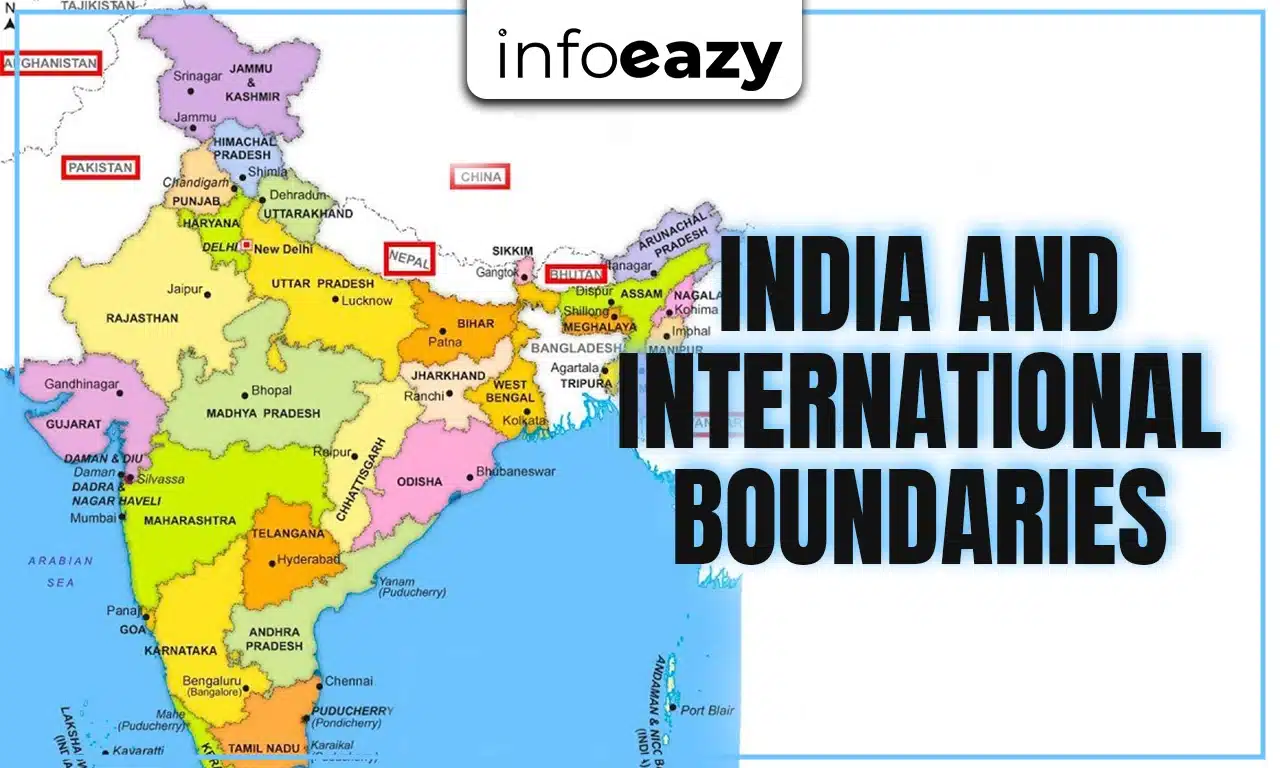
India is the seventh-largest country in the world and has one of the longest international boundaries. These borders separate India from its neighboring countries and also help in maintaining its security, trade, and cultural exchange. The international boundaries of India include both land borders and maritime borders, making it strategically important in South Asia. Understanding these boundaries is very important for competitive exams as they are often asked in questions related to geography, polity, and current affairs.
International Boundaries of India
The international boundaries of India, both land and maritime, are vital for the country’s geography, defense, economy, and culture. With seven neighboring countries and a long coastline, India’s borders make it a strategically important nation in South Asia. For competitive exams, remembering the length of borders, states sharing them, and related issues is very important. As India grows stronger, maintaining peaceful and secure boundaries remains one of its top priorities.
Also Read: Operation Sindoor
International Boundaries of India: Overview
India shares its boundaries with several countries through land and sea. The total length of India’s land border is about 15,106 kilometers, while the maritime boundary is about 7,516.6 kilometers, including the mainland and island territories. These boundaries not only define India’s geographical identity but also influence its defense, economy, and foreign policy.
| International Boundaries of India: Overview | |
| Type of Boundary | Length (Approx.) |
| Land Borders | 15,106 km |
| Maritime Borders | 7,516.6 km |
| Coastline (Mainland + Islands) | 7,516.6 km |
| Total Area Covered | 32,87,263 sq. km |
Land Boundaries of India
India shares land borders with seven countries and has a total land boundary length of 15,106 kilometers. Out of these, China, Pakistan, and Bangladesh share the longest borders. Each border is important for trade, defense, and cultural ties. Fact: India’s border with Bangladesh is the longest, while its border with Afghanistan (Wakhan Corridor) is the shortest.
| Countries Sharing Land Borders with India | ||
| Country | Length of Border (km) | States/ UTs Sharing Border |
| Bangladesh | 4,096 km | West Bengal, Assam, Meghalaya, Tripura, Mizoram |
| China | 3,488 km | Jammu & Kashmir (Ladakh), Himachal Pradesh, Uttarakhand, Sikkim, Arunachal Pradesh |
| Pakistan | 3,323 km | Jammu & Kashmir, Punjab, Rajasthan, Gujarat |
| Nepal | 1,751 km | Uttarakhand, Uttar Pradesh, Bihar, West Bengal, Sikkim |
| Myanmar | 1,643 km | Arunachal Pradesh, Nagaland, Manipur, Mizoram |
| Bhutan | 699 km | Sikkim, West Bengal, Assam, Arunachal Pradesh |
| Afghanistan | 106 km | Ladakh (Union Territory) |
Maritime Boundaries of India
Apart from land borders, India also has long maritime boundaries that touch the Indian Ocean, Arabian Sea, and Bay of Bengal. The total length of the maritime boundary is 7,516.6 km, which includes both mainland and island territories such as the Andaman & Nicobar Islands and Lakshadweep Islands.
Key Facts about India’s Maritime Boundaries:
- India’s coastline passes through 9 states and 2 Union Territories.
- Important states with a long coastline: Gujarat, Maharashtra, Tamil Nadu, Andhra Pradesh, and Odisha.
- Strategic points include the Strait of Malacca near the Andaman & Nicobar Islands, which is one of the busiest sea routes in the world.
| States/ UTs with Coastline | |
| State/ UT | Coastline Length (km) |
| Gujarat | 1,214 km |
| Andhra Pradesh | 974 km |
| Tamil Nadu | 906 km |
| Maharashtra | 652 km |
| Kerala | 569 km |
| Odisha | 476 km |
| Karnataka | 280 km |
| West Bengal | 158 km |
| Goa | 160 km |
| Andaman & Nicobar Islands | 1,962 km |
| Lakshadweep Islands | 132 km |
Importance of India’s International Boundaries
The international boundaries of India are not just lines on the map, they play a very important role in the nation’s progress and security.
- Security: India faces cross-border challenges with Pakistan and China, making these boundaries highly sensitive.
- Trade: Borders with Bangladesh, Nepal, Bhutan, and Myanmar are important for regional trade and cooperation.
- Cultural Links: Shared borders allow cultural and historical ties, especially with Nepal, Bhutan, and Bangladesh.
- Maritime Importance: Coastal boundaries provide opportunities for international trade through major ports like Mumbai, Chennai, and Kolkata.
Challenges at the International Boundaries of India
India’s international borders are often in the news due to disputes and challenges. Some key issues include:
- Border Disputes with China: The Line of Actual Control (LAC) remains disputed in Ladakh and Arunachal Pradesh.
- Border Issues with Pakistan: The Line of Control (LoC) in Jammu & Kashmir sees frequent tensions.
- Illegal Migration: Especially across the Bangladesh border.
- Smuggling & Infiltration: Drugs, weapons, and human trafficking across porous borders.
- Maritime Security: Piracy and illegal fishing in the Indian Ocean pose challenges.
Line of Actual Control (LAC)
The Line of Actual Control (LAC) is the boundary between India and China. It is not an officially demarcated border but a line that separates Indian-controlled areas from Chinese-controlled areas. The LAC covers a length of about 3,488 km across Ladakh, Himachal Pradesh, Uttarakhand, Sikkim, and Arunachal Pradesh.
- It was created after the 1962 Sino-Indian War.
- The LAC is divided into three sectors: Western sector (Ladakh), Middle sector (Himachal Pradesh & Uttarakhand), and Eastern sector (Sikkim & Arunachal Pradesh).
- Disputes arise because India and China interpret the LAC differently, which often leads to standoffs like the Galwan Valley clash of 2020.
Line of Control (LoC)
The Line of Control (LoC) is the boundary line between India and Pakistan in the Jammu & Kashmir region. It is about 776 km long and was established after the 1947-48 Indo-Pak war, later formalized in the Simla Agreement of 1972.
- Unlike the LAC, the LoC is clearly demarcated on maps and marked with fencing in many areas.
- It is heavily guarded by both the Indian and Pakistani armies.
- The LoC often sees ceasefire violations, infiltration, and cross-border firing, making it one of the most sensitive boundaries in the world.
- Major areas along the LoC include Siachen Glacier, Poonch, and Rajouri.
International Boundaries of India FAQs
Q1. How many countries share land borders with India? +
Q2. Which country shares the longest border with India? +
Q3. What is the length of India’s coastline? +
Q4. Which states of India share borders with China? +
Q5. Why are India’s maritime boundaries important? +
Tags: International International Boundaries International Boundaries of India