Himachal Pradesh is a State in Northern India. It is known for its scenic beauty, Himalayan landscapes, and vibrant culture. It is also known as Deva Bhoomi. It is one of the Least Populated States in India and ranks 21st in terms of area. Himachal Pradesh has 12 districts, and each district is administered by a Deputy Commissioner from the Indian Administrative Service (IAS). A Deputy Conservator of Forests, of the Indian Forest Service (IFS), is responsible for managing the Forests, environment, and flora-fauna related issues of the district.
Districts of Himachal Pradesh
Himachal Pradesh has an area of 55,673 Sq.Km. which is divided into 12 Districts, grouped into 3 administrative divisions. The most populous district of Himachal Pradesh is Kangra, while Lahaul & Spiti is the Largest District of the state with an area of 13,833 sq. km. Km. Each district showcases unique geographical features, cultural heritage, and economic activities, reflecting the rich diversity of this Himalayan state.
Also Read: Districts of Andhra Pradesh
List of Districts of Himachal Pradesh
Himachal Pradesh has 12 districts grouped into 3 divisions. The state was established on 25th January 1971, and since its formation, the district structure has evolved in accordance with administrative and geographical considerations. Here is a List of Districts of Himachal Pradesh with relevant details:
| List of Districts of Himachal Pradesh | ||||
| Sl. No | District | Population | Area (km²) | Formed |
| 1 | Bilaspur | 381,956 | 1,167 | 1954 |
| 2 | Chamba | 519,080 | 6,522 | 1948 |
| 3 | Hamirpur | 454,768 | 1,118 | 1972 |
| 4 | Kangra | 1,510,075 | 5,739 | 1972 |
| 5 | Kinnaur | 84,121 | 6,401 | 1960 |
| 6 | Kullu | 437,903 | 5,503 | 1963 |
| 7 | Lahaul and Spiti | 31,564 | 13,835 | 1960 |
| 8 | Mandi | 999,777 | 3,950 | 1948 |
| 9 | Shimla | 814,010 | 5,131 | 1972 |
| 10 | Sirmaur | 529,855 | 2,825 | 1948 |
| 11 | Solan | 580,320 | 1,936 | 1972 |
| 12 | Una | 521,173 | 1,540 | 1972 |
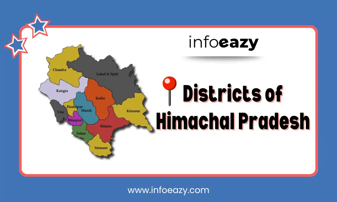
Districts of Himachal Pradesh Map
Districts of Himachal Pradesh Map includes the location of each district in the state, which will help the candidates to understand and grasp the location of the district with their sizes:
Largest District of Himachal Pradesh
Lahaul and Spiti is the Largest District in Himachal Pradesh in terms of area, spanning approximately 13,835 sq. km. Located in the northern part of the state, it is known for its beautiful landscapes and Tibetan-influenced culture. The district is a popular destination for adventure tourism and Buddhist heritage.
Smallest District of Himachal Pradesh
Hamirpur is the Smallest District in Himachal Pradesh, covering an area of around 1,118 sq. km. Hamirpur has established itself as an education hub with several institutions, including Himachal Pradesh Technical University, Dr. Radha Krishnan Government Medical College, and National Institute of Technology Hamirpur. It is also known as Veer Bhoomi, given that a high number of defense personnel originating from the region.
Divisions of Himachal Pradesh
Himachal Pradesh’s 12 districts are organized into 3 divisions. Kangra is the Largest Division in terms of area, comprising 4 districts. Below is an overview of the divisions of Himachal Pradesh:
| Divisions of Himachal Pradesh | |
| Division | District |
| Kangra | Chamba, Kangra, Una |
| Mandi | Bilaspur, Hamirpur, Kullu, Lahaul and Spiti, Mandi |
| Shimla | Kinnaur, Shimla, Sirmaur, Solan |
Districts of Himachal Pradesh FAQs
Q1. How many districts are there in Himachal Pradesh?+
Q2. Which is the Largest District in Himachal Pradesh by area?+
Q3. What is the Smallest District in Himachal Pradesh?+
Q4. Which District is the Capital of Himachal Pradesh?+
Q5. Which Districts of Himachal Pradesh share a border with China?+


