Rajasthan, the Largest State in India by area, is now administratively divided into 50 districts. Initially, the Chief Minister announced the creation of 19 new districts, expanding the total from 33 to 50. Each district is administered by a District Magistrate and a Superintendent of Police, ensuring effective governance and law enforcement.
These districts are organized under seven administrative divisions, Ajmer, Kota, Jaipur, Bharatpur, Bikaner, Jodhpur, and Udaipur to facilitate better management and regional coordination. Among the more recent additions is the district of Pratapgarh, established in 2008.
Districts of Rajasthan
Rajasthan is located in the northwestern part of the country which is known for its royal heritage, desert landscapes, and historical forts, Rajasthan has a well-organized administrative structure divided into multiple districts. These districts serve as crucial administrative units, playing a key role in governance, planning, and development. Each district is headed by a District Collector and has its own headquarters. The state government periodically reviews and modifies the district boundaries for better administration. As of 2024, there are 50 Districts of Rajasthan.
List of Districts of Rajasthan
Over the years, there has been a growing demand for the creation of additional districts to enhance administrative efficiency and local governance. Rajasthan was officially formed on 30 March 1949 and later reorganized in 1956, along with the creation of 26 new states. Since then, the state has seen the gradual addition of several districts, contributing to its current administrative structure.
The table below provides the List of Districts of Rajasthan, detailing their respective area and population statistics for better understanding of the state’s administrative geography.
| List of Districts of Rajasthan | |||
| S.No | District | Area (km²) | Population (2011) |
| 1 | Anupgarh | 4713.96 | 698,478 |
| 2 | Ajmer | 8481 | 2,583,052 |
| 3 | Alwar | 8380 | 3,674,179 |
| 4 | Balotra | 19000 | 970760 |
| 5 | Banswara | 5037 | 1,797,485 |
| 6 | Baran | 6992 | 1,222,755 |
| 7 | Barmer | 28387 | 2,603,751 |
| 8 | Beawar | 1734 | 342935 |
| 9 | Bharatpur | 5066 | 4,125,512 |
| 10 | Bhilwara | 10455 | 2,408,523 |
| 11 | Bikaner | 30247 | 2,363,937 |
| 12 | Bundi | 5550 | 1,110,906 |
| 13 | Chittorgarh | 7822 | 1,544,338 |
| 14 | Churu | 13858 | 2,039,547 |
| 15 | Dausa | 3432 | 1,634,409 |
| 16 | Dholpur | 3084 | 1,206,516 |
| 17 | Dungarpur | 3770 | 1,388,552 |
| 18 | Hanumangarh | 9656 | 1,774,692 |
| 19 | Jaisalmer | 38401 | 669,919 |
| 20 | Jalore | 10640 | 1,828,730 |
| 21 | Jhalawar | 6928 | 1,411,129 |
| 22 | Jhunjhunu | 5928 | 2,137,045 |
| 23 | Karauli | 5043 | 1,458,248 |
| 24 | Kota | 5217 | 1,951,014 |
| 25 | Nagaur | 17718 | 3,307,743 |
| 26 | Pali | 12387 | 2,037,573 |
| 27 | Pratapgarh | 3730 | 3,209,141 |
| 28 | Rajsamand | 4550.93 | 1,156,597 |
| 29 | Sawai Madhopur | 10527 | 1,335,551 |
| 30 | Sikar | 5191.44 | 1,694,094 |
| 31 | Sirohi | 5136 | 1,036,346 |
| 32 | Sri Ganganagar | 11154.66 | 1,969,168 |
| 33 | Tonk | 7194 | 1,421,326 |
| 34 | Udaipur | 11724 | 3,068,420 |
| 35 | Dudu | 52.08 | 184960 |
| 36 | Deeg | 505 | 1,072,755 |
| 37 | Didwana Kuchaman | 679 | 1,625,837 |
| 38 | Gangapur | 2558 | 1,65,000 |
| 39 | Jaipur Rural | 11,061.44 | 1,922,210 |
| 40 | Jodhpur Rural | 4713.96 | 698,478 |
| 41 | Kekri | 8481 | 2,583,052 |
| 42 | Khairthal–Tijara | 8380 | 3,674,179 |
| 43 | Kotputli-Behror | 2920 | 1,271,426 |
| 44 | Neem Ka Thana | 5037 | 1,797,485 |
| 45 | Phalodi | 6992 | 1,222,755 |
| 46 | Sanchore | 28387 | 2,603,751 |
| 47 | Salumbar | 2480 | 570,775 |
| 48 | Shahpura | 3808 | 723,208 |
| 49 | Jaipur | 789.52 | 34,71,847 |
| 50 | Jodhpur | 4,467.3 | 1,137,815 |
Largest District of Rajasthan
The Largest District of Rajasthan by area is Jaisalmer. It spans approximately 38,401 square kilometers, making it not only the biggest in the state but also one of the Largest District in India. Located in the western part of the state, Jaisalmer is known for its vast Thar Desert, sand dunes, and historical forts. The district shares an international border with Pakistan and holds strategic importance due to its geographical location.
Smallest District of Rajasthan
The Smallest District of Rajasthan in terms of area is Dungarpur. Covering an area of around 3,770 square kilometers, Dungarpur is located in the southern part of the state, near the Gujarat border. Despite its smaller size, the district is known for its tribal population, green landscapes, and rich cultural heritage. It plays a vital role in the socio-economic development of the Vagad region.
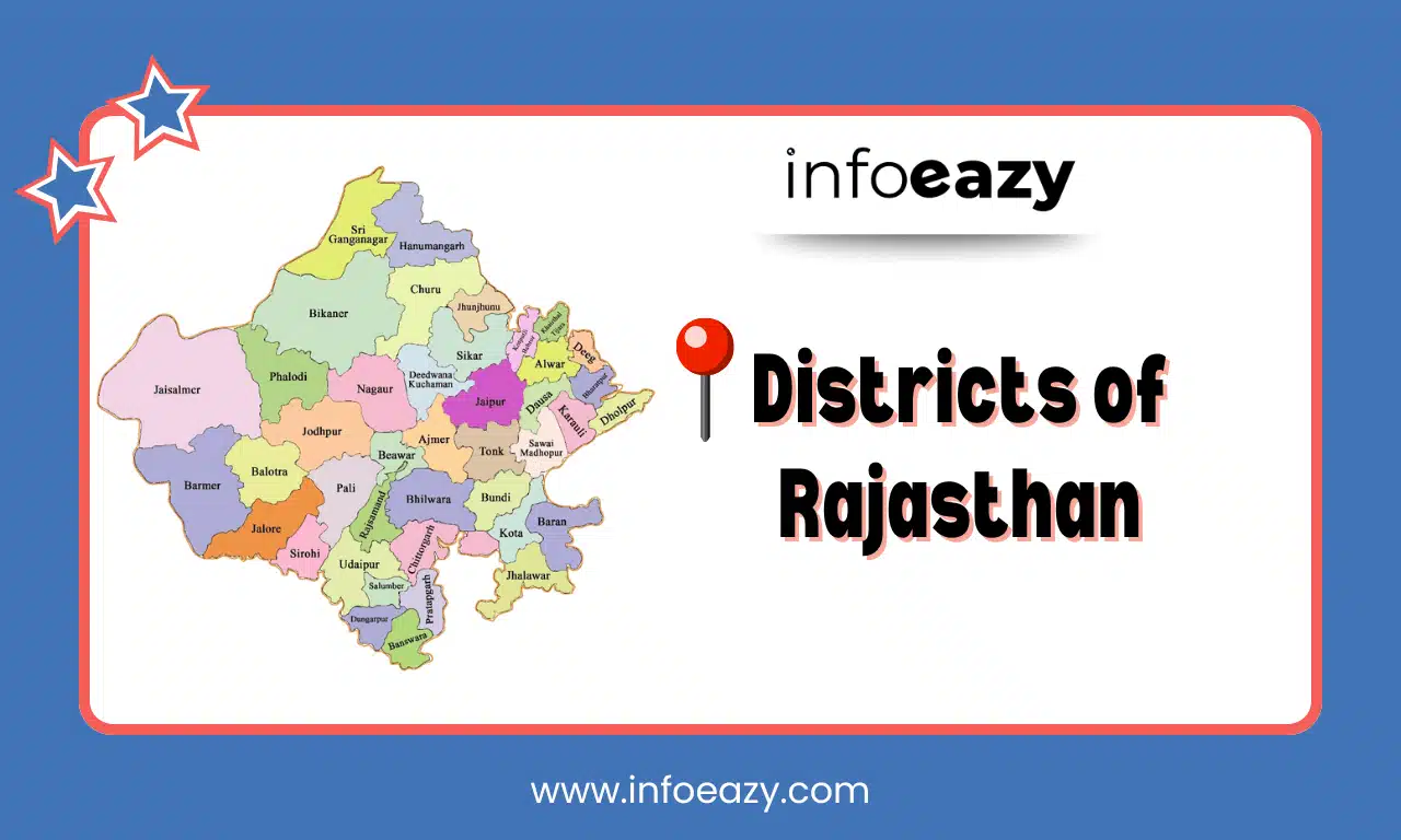
Districts of Rajasthan Map
The Districts of Rajasthan Map with its 50 districts provides a clear visual representation of the state’s administrative boundaries. It highlights the geographical spread, district headquarters, and proximity of districts to each other.
Districts of Rajasthan FAQs
Q1. How many districts are there in Rajasthan in 2024?+
Q2. Which is the newest district of Rajasthan?+
Q3. What is the capital of Rajasthan?+
Q4. What is the significance of district-level administration?+
Q5. Which districts border Pakistan?+
Tags: Districts of Rajasthan