Nagaland is a state located in the northeastern region of India, known for its rich tribal culture, scenic landscapes, and vibrant festivals. Established as the 16th state of India on 1st December 1963, Nagaland shares its borders with Assam to the west, Arunachal Pradesh and part of Assam to the north, Myanmar to the east, and Manipur to the south.
The state is predominantly inhabited by 16 major tribes, each having distinct customs, languages, and traditional practices. For administrative convenience and efficient governance, Nagaland has been divided into several districts. These Districts of Nagaland serve as important administrative units and play a vital role in development planning and implementation.
Districts of Nagaland
Nagaland shares its borders with Assam, Manipur, Arunachal Pradesh, and also with the international boundary of Myanmar. As of today, Nagaland comprises 16 districts, each with its own distinct identity and cultural significance. The Districts of Nagaland are further divided into subdivisions for administrative convenience. When Nagaland was officially established as a state on December 1, 1957, it had only three districts, Kohima, Mokokchung, and Tuensang. Over the years, the number of districts increased to improve governance and bring administration closer to the people. Each district is governed by a Deputy Commissioner or District Collector, responsible for maintaining law and order and overseeing development initiatives.
List of Districts of Nagaland
As of 2025, there are 16 Districts of Nagaland, each governed by a Deputy Commissioner. The districts vary significantly in terms of area, population, and development indices. Below is the list of all districts in Nagaland:
| List of Districts of Nagaland | |||
| S No. | District | Population | Area |
| 1 | Kohima | 267988 | 1207 |
| 2 | Mokokchung | 194622 | 1719 |
| 3 | Tuensang | 137296 | 2536 |
| 4 | Wokha | 166343 | 1628 |
| 5 | Zunheboto | 140757 | 1255 |
| 6 | Phek | 163418 | 2026 |
| 7 | Dimapur | 170000 | 70 |
| 8 | Kiphire | 74004 | 1130 |
| 9 | Longleng | 50484 | 562 |
| 10 | Peren | 95219 | 2300 |
| 111 | Noklak | 1152 | 59300 |
| 12 | Niuland | N/A | 11876 |
| 13 | Shamator | – | 12726 |
| 14 | Tseminyü | 256 | 63629 |
| 15 | Chümoukedima | 125400 | 610 |
| 16 | Mon | 1786 | 250260 |
Note: The newly created districts like Chümoukedima, Niuland, Shamator, and Tseminyu were carved out between 2021 and 2022 for better administrative efficiency.
Largest District of Nagaland
The Largest District of Nagaland in terms of area is Tuensang. Located in the eastern part of the state, Tuensang covers a geographical area of approximately 2,536 square kilometers. It is one of the most significant districts, both in terms of size and historical importance. Tuensang also shares an international border with Myanmar, making it strategically important. The district is home to multiple tribes such as Chang, Sangtam, Yimkhiung, Khiamniungan, and others, contributing to its rich cultural diversity. Despite its size, Tuensang is considered less developed compared to the central and western districts, which continue to be a focus for governmental developmental initiatives.
Smallest District of Nagaland
Niuland is the Smallest District of Nagaland by area. It was carved out of the Dimapur district in 2021 and functions with its own administrative machinery. Niuland is located in the southwestern part of Nagaland and is comparatively urbanised due to its proximity to Dimapur, which is the commercial hub of the state. The area of Niuland is relatively small, and it includes fewer administrative subdivisions. The formation of this district aimed to bring administration closer to the people and ensure more focused development for the region.
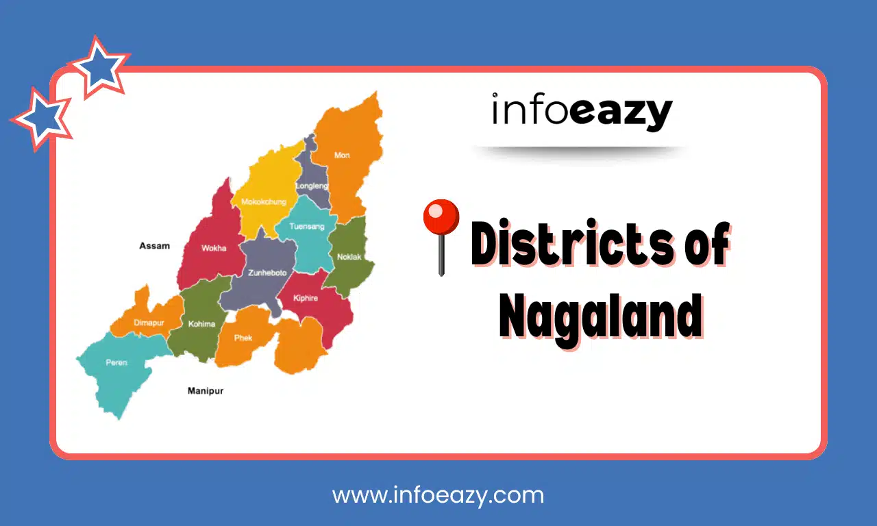
Districts of Nagaland Map
A Districts of Nagaland Map provides a visual representation of the geographical distribution and boundaries of all 16 districts. The map is essential for understanding the layout of the state.
Districts of Nagaland FAQs
Q1. How many districts are there in Nagaland as of 2025?+
Q2. Which is the largest district in Nagaland by area?+
Q3. Which is the smallest district in Nagaland?+
Q4. Which is the most populated district in Nagaland?+
Q5. Why were new districts created in Nagaland recently?+
Tags: Districts of Nagaland