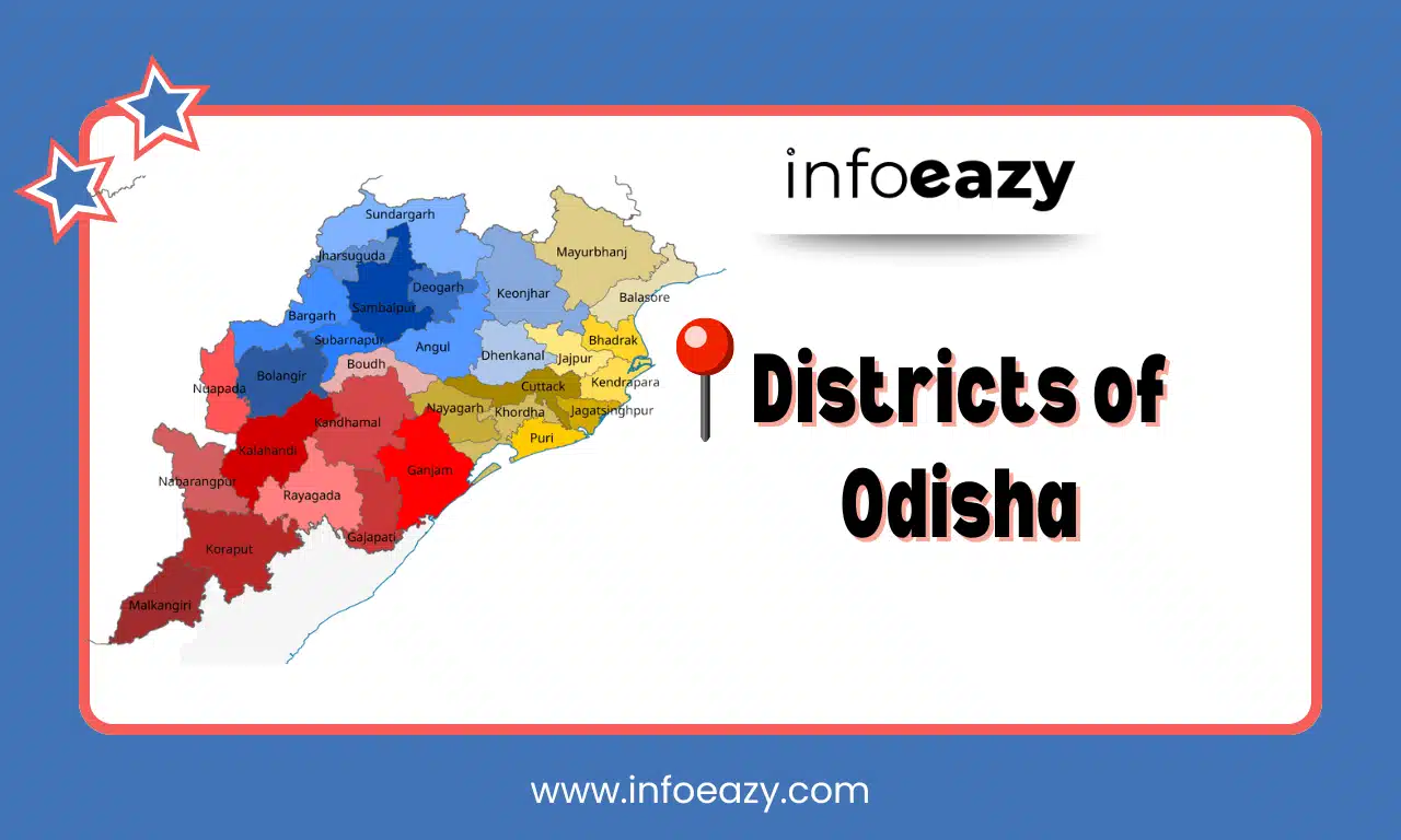
Odisha, located on India’s eastern coast, spans roughly 154,469 km² and had a population of around 41.97 million in 2011. Initially formed in 1936 with just five districts, the state has expanded to its current 30 districts, grouped under three revenue divisions for efficient administration. Each district is headed by a District Collector & Magistrate responsible for revenue, law and order, and developmental activities, and further subdivided into Sub‑Divisions, Tehsils, and Blocks.
Districts of Odisha
Odisha, located on the eastern coast of India, currently comprises 30 administrative districts. When the province of Odisha was officially formed on April 1, 1936, it began with just five districts. Over time, to improve administrative efficiency and ensure better governance, the state underwent multiple reorganizations leading to the creation of new districts. Today, each of the 30 Districts of Odisha functions as an individual administrative unit, managed by a District Magistrate (DM) and Collector who oversee law and order, revenue collection, and development programs.
List of Districts of Odisha
The Districts of Odisha are listed below, along with their administrative headquarters and Census 2011 area & population figures.
| List of Districts of Odisha | |||
| SL. No | Districts | Area | Population |
| 1 | Angul | 6,375 | 1,273,821 |
| 2 | Boudh | 3444.8 | 441,162 |
| 3 | Balangir | 6,575 | 1,648,997 |
| 4 | Bargarh | 5,837 | 1,481,255 |
| 5 | Balasore | 3,634 | 2,320,529 |
| 6 | Bhadrak | 2,505 | 1,506,337 |
| 7 | Cuttack | 3,932 | 2,624,470 |
| 8 | Debagarh | 2,782 | 312,520 |
| 9 | Dhenkanal | 4,452 | 1,192,811 |
| 10 | Ganjam | 8,206 | 3,529,031 |
| 11 | Gajapati | 3,850 | 577,817 |
| 12 | Jharsuguda | 2,081 | 579,505 |
| 13 | Jajpur | 2887.69 | 1,827,192 |
| 14 | Jagatsinghapur | 1,759 | 1,136,971 |
| 15 | Khordha | 2,813 | 2,251,673 |
| 16 | Kendujhar | 8,303 | 1,801,733 |
| 17 | Kalahandi | 7,920 | 1,576,869 |
| 18 | Kandhamal | 7,654 | 733,110 |
| 19 | Koraput | 8,807 | 1,379,647 |
| 20 | Kendrapara | 2,644 | 1,440,361 |
| 21 | Malkangiri | 5,791 | 613,192 |
| 22 | Mayurbhanj | 10,418 | 2,519,738 |
| 23 | Nabarangpur | 5,294 | 1,220,946 |
| 24 | Nuapada | 3,852 | 610,382 |
| 25 | Nayagarh | 3,890 | 962,789 |
| 26 | Puri | 3,051 | 1,698,730 |
| 27 | Rayagada | 7,073 | 967,911 |
| 28 | Sambalpur | 6,702 | 1,041,099 |
| 29 | Subarnapur | 2,337 | 610,183 |
| 30 | Sundargarh | 9,712 | 2,093,437 |
Administrative Structure of Districts in Odisha
The 30 Districts in Odisha are managed under three revenue divisions: Cuttack, Sambalpur, and Berhampur, each overseen by a Divisional Commissioner. District Collectors handle administration, law and order, disaster response, and implementation of schemes.
| Administrative Structure of Districts in Odisha | |||
| S.no | Northern | Central | Southern |
| 1 | Sambalpur | Cuttack | Ganjam |
| 2 | Jharsuguda | Kendrapara | Kandhamal |
| 3 | Bargarh | Jagatsinghpur | Gajapati |
| 4 | Debagarh | Jajpur | Bodh |
| 5 | Balangir | Puri | Kalahandi |
| 6 | Subarnapur | Khordha | Nuapada |
| 7 | Dhenkanal | Nayagarh | Koraput |
| 8 | Angul | Balasore | Rayagada |
| 9 | Kendujhar | Bhadrak | Nabarangpur |
| 10 | Sundargarh | Mayurbhanj | Malkangiri |
Largest District of Odisha
By area, Mayurbhanj is the Largest District of Odisha, covering 10,418 km², making it nearly the size of several small states and home to the Similipal Biosphere Reserve. By population, Ganjam leads with approximately 3.53 million people, reflecting its urban-rural mix and coastal economy.
Smallest District of Odisha
By area, Jagatsinghpur is the Smallest District of Odisha, spanning just 1,668-1,759 km², carved from Cuttack in 1993. By population, Debagarh, with about 312,520 people, is the least populated.
Districts of Odisha Map
Explore the administrative layout and geographical view of Districts of Odisha including Coastal districts, terrain-linked and District boundaries which are crucial in understanding local governance and disaster zones.
Districts of Odisha FAQs
Q1. How many districts are there currently?+
Q2. Which is the largest district by area?+
Q3. Which is the smallest district by area?+
Q4. Which district has the highest population?+
Q5. Which district has the lowest population?+
Tags: Districts of Odisha


