The Ganga River System is one of the major river systems in India, originating from the Himalayas and flowing across the northern and eastern regions of the country. It plays a crucial role in supporting millions of people by providing water for agriculture, drinking, and various other needs. The river also sustains a rich diversity of ecosystems along its extensive course. The Ganga River System forms a part of the Himalayan Drainage System, one of the three principal river basins in India.
Along with its tributaries, the river shapes the northern and eastern landscapes of the Indian subcontinent. Spanning a length of over 2,500 kilometres, the Ganga is not only the most significant river in India but also ranks among the Longest Rivers in Asia.
Ganga River System Origin
The Ganga River System begins as the Bhagirathi River, emerging from the Gangotri Glacier (Gaumukh) at around 3,892 m in Uttarakhand. It meets the Alaknanda River at Devprayag, after which it is called the Ganga proper. The Alaknanda, considered hydrologically true source, originates from glaciers like Satopanth and Bhagirathi-Kharak, with major tributaries such as Mandakini, Pindar, and Nandakini before Devprayag.
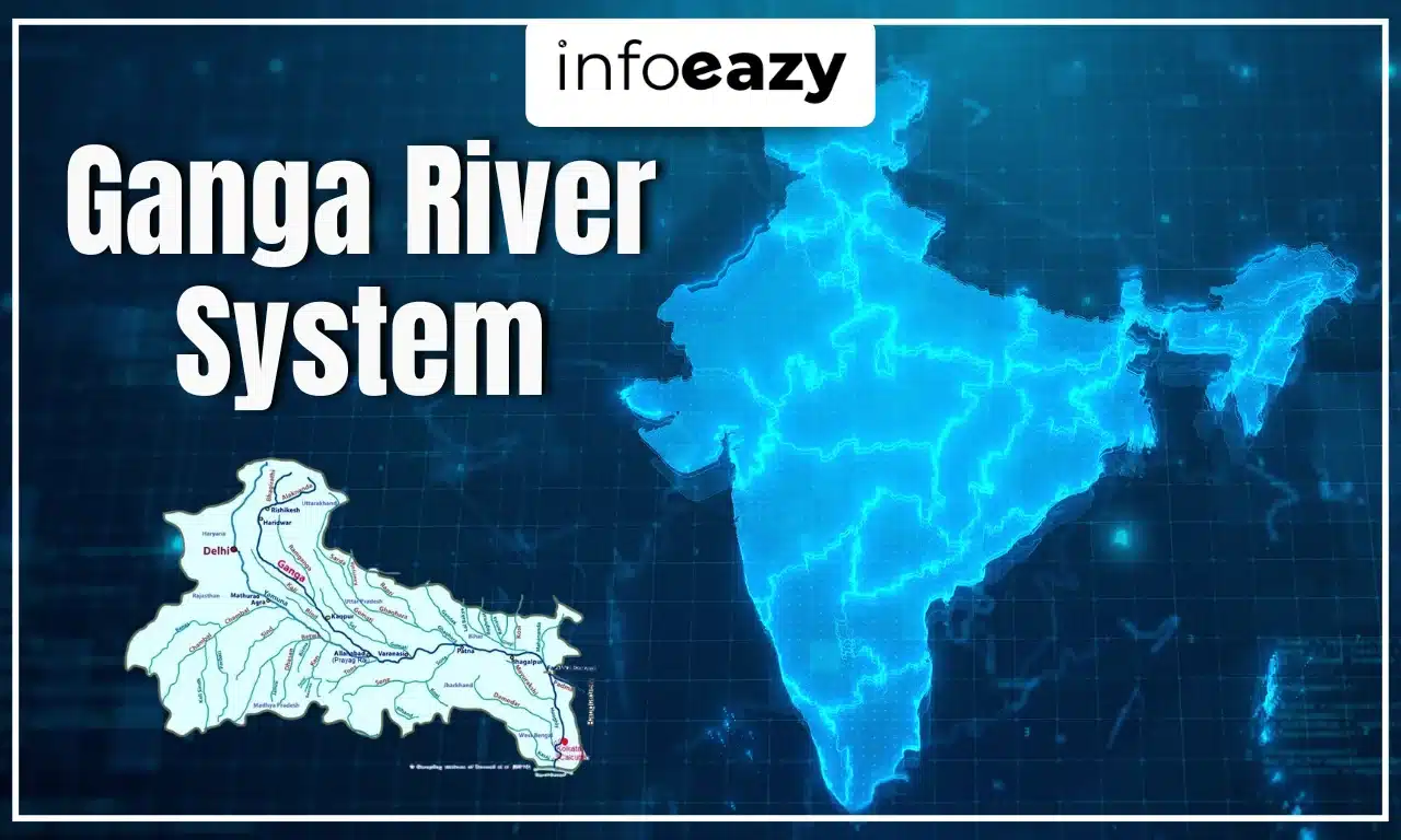
Ganga River System Map
The Ganga River System spans the Himalayas and the Indo-Gangetic plain across Uttarakhand, Uttar Pradesh, Bihar, Jharkhand, and West Bengal, finally merging into the Bay of Bengal via the Ganga–Brahmaputra delta. Along its journey, it receives water from major tributaries, flows past historic cities, and branches into distributaries like the Hooghly (Bhagirathi) and Padma near Farakka, before merging with the Brahmaputra in Bangladesh.
Ganga River System Tributaries
These Ganga River System Tributaries contribute significant water volume and sediment, shaping the Ganga basin’s ecological and agricultural dynamics:
| Ganga River System Tributaries |
| Name of Tributary |
Description |
| Yamuna |
- The Yamuna River is the largest tributary of the Ganga River system in terms of water volume.
- It originates from the Yamunotri Glacier, located in the lower Himalayas of Uttarakhand. This glacier lies at an elevation of approximately 6,387 meters above sea level, near the Bandarpoonch peaks in the Mussoorie range within Uttarkashi district.
- Covering around 1,376 kilometers, the river flows through multiple Indian states, including Uttarakhand, Haryana, Uttar Pradesh, and Delhi, before finally merging with the Ganga at Prayagraj in Uttar Pradesh. Its major tributaries include the Tons, Asan, Giri, Ken, Betwa, Chambal, Sind, Rind, and Hindon rivers.
|
| Son Nadi |
- It is the second-largest southern tributary of the Ganga and flows through central India.
- Originating near Amarkantak in Madhya Pradesh, just east of the Narmada River’s source, it initially flows through Madhya Pradesh before taking a sharp eastward turn towards the Kaimur Range.
- The river passes through the states of Madhya Pradesh, Chhattisgarh, Jharkhand, and Bihar, eventually merging with the Ganga near Patna in Bihar.
|
| Punpun |
- Originating in the Palamu district of Jharkhand, this river flows through Chhatra, Aurangabad, Gaya, and Patna, covering regions in both Jharkhand and Bihar.
- Following a northeastward path, it eventually merges with the Ganga at Fatuha in Patna, Bihar.
|
| Falgu |
- Falgu is also known as the Phalgu or Niranjana River, it is a significant waterbody in Bihar.
- The Falgu River is an important site for tourism and pilgrimage, holding great spiritual significance, especially in Buddhism, as it is believed to be the place where Lord Buddha attained enlightenment.
- Flowing through the districts of Chatra and Gaya in Jharkhand and Bihar, it eventually merges with the Punpun River.
|
| Kiul |
- Kiul originates in the Giridih district of Jharkhand, which flows through the Sheikhpura, Jamui, and Lakhisarai districts of Bihar before merging with the Ganga near Surajgarha.
- It spans a length of 110 kilometers and drains an area of approximately 16,500 square kilometers.
|
| Chandan |
- Chandan flows near the city of Bhagalpur in the Indian state of Bihar, also known by the name of Champa River, which is the historical name of the river.
|
| Ajay |
- The Ajay River originates on the gentle slopes near the Deoghar Hills in the Santhal Pargana district of Jharkhand.
- Flowing through Jharkhand and Bihar, it eventually reaches its endpoint in Simjuri, West Bengal.
|
| Damodar |
- It is a major tributary of the Ganga River, originating from the Palamau Hills in the Chota Nagpur Plateau, Jharkhand, at an altitude of approximately 610 meters.
- Flowing in a southeasterly direction, it travels through several districts in Jharkhand and West Bengal before finally merging with the Hooghly River, around 48 kilometers downstream of Kolkata.
|
| Rupnarayan |
- Originating from Dhaleswari (Dhalkisor) in the foothills of the Chhota Nagpur Plateau, this river flows towards Bankura, where it merges with the Dwarkeshwar River.
|
| Tamsa |
- The Tamsa River, a tributary of the Ganga, originates from Tamakund in the Kaimur Range at an elevation of 610 meters.
- It flows through the states of Madhya Pradesh and Uttar Pradesh before merging with the Ganga.
|
| Karamnasa |
- It is a minor tributary of the Ganga, originating in the Kaimur district of Bihar.
- The river flows through the states of Bihar and Uttar Pradesh before joining the Ganga.
|
| Ramganga (Western) |
- It is the first major tributary of the Ganga, originating from the southern slopes of the Doodhatoli ranges in Uttarakhand’s Chamoli district.
- Flowing through Corbett National Park near Ramnagar in the Nainital district, it then descends into the plains.
- Spanning a length of 596 kilometers, the Ramganga River merges with the Ganga near Kannauj in Uttar Pradesh.
|
| Garra |
- Originating in the Kumaon Hills of Uttarakhand, this river is a tributary of the Ganga.
- It flows through several regions, including the major industrial areas of Shahjahanpur in Uttar Pradesh.
|
| Gomti |
- An important tributary of the Ganga, it originates from Fulhaar Jheel, a lake situated in Madhotanda, approximately 30 km east of Pilibhit town in Uttar Pradesh.
- The lake, located at an elevation of 185 meters above sea level, serves as the source of the Gomti River, which flows southeast through the Ganga Plain.
|
| Ghaghara |
- Also known as Karnali or Manchu in its upper reaches, this river is a significant tributary of the Ganga.
- It originates from the Mapchachungo glaciers at an altitude of about 3,962 meters on the southern slopes of the Himalayas in Tibet.
- Flowing southeast, it passes through Uttar Pradesh and Bihar before merging with the Ganga.
- Spanning a length of 1,080 km, its major tributaries include the Sarju, Sharda, Rapti, and Chhoti Gandak rivers.
- The river has a catchment area of approximately 127,000 square kilometers, with 45% of it lying within India.
|
| Gandak |
- A major river in both Nepal and India, it originates at an altitude of 7,620 meters near the north Dhaulagiri peak in Tibet, close to the Nepal border.
- In Nepal, it is known as the Narayani and Kali Gandaki after merging with the Trisuli River.
- The river has a total catchment area of 46,300 square kilometers, with 7,620 square kilometers falling within India.
|
| Burhi Gandak |
- Originating from a spring in the Someshwar Hills at an elevation of 300 meters in the West Champaran district of Bihar, this river is also known as Sikrchana in its upper reaches.
|
| Kosi |
- One of the major rivers in Nepal and India, it originates from the Himalayan region of Nepal and Tibet.
- Also known as Saptakoshi, it is formed by the confluence of three streams—the Sun Kosi, Arun Kosi, and Tamur Kosi.
- Upon entering northern Bihar, India, it splits into multiple distributaries before merging with the Ganga near Kursela in the Katihar district of Bihar.
- Often referred to as “Bihar’s Sorrow” due to its frequent and intense flooding, it carries the highest amount of silt and sand in India after the Brahmaputra.
|
Cities on the banks of Ganga River System
The Ganga River System flows past several prominent towns and cities, supporting both spiritual and developmental hubs:
- Srinagar, Rishikesh, Haridwar, and Roorkee in Uttarakhand
- Bijnor, Narora, Kannauj, Kanpur, Prayagraj, Varanasi, Mirzapur in Uttar Pradesh
- Patna and Bhagalpur in Bihar
- Beharampore, Serampore, Howrah, and Kolkata in West Bengal
These cities are centers of pilgrimage, learning, industry, and transport along the river’s course.
Panch Prayag (Ganga River)
‘Panch Prayag’ refers to the five sacred confluences of the Alaknanda River in Uttarakhand. These sites are embedded in Hindu mythology, forming part of the Char Dham pilgrimage, and are also major hydro-geographical junctions. These are revered pilgrimage sites and hydrologically significant junctions:
| Panch Prayag (Ganga River) |
| Place of Confluence |
River System |
| Devprayag |
Bhagirathi and Alaknanda |
| Rudraprayag |
Mandakini and Alaknanda |
| Nandaprayag |
Nandakini and Alaknanda |
| Karnaprayag |
Pindar and Alaknanda |
| Vishnuprayag |
Dhauliganga and Alaknanda |
Ganga-Brahmaputra Delta
Before meeting the Bay of Bengal, the Ganga merges with the Brahmaputra (Jamuna in Bangladesh) and Meghna, forming the world’s Largest Delta. This delta spans over 60,000 sq km, with a highly intricate network of distributaries and mangrove islands, including the Sundarbans, which consists of low-lying swamps that frequently cause flooding by seawater during high tides.
Also Read: Kaziranga National Park
Ganga River System Importance
The Ganga River System is crucial for multiple dimensions:
- Economic Lifeline: Provides irrigation, drinking water, hydropower, and riverine transport to millions across its basin
- Cultural & Religious: Revered in Hinduism; cities like Haridwar, Varanasi, and Prayagraj are spiritual epicenters.
- Ecological Support: Supports the world’s most extensive fertile plains and contributes to biodiversity in the delta.
- Delta Shield: The Sundarbans Delta acts as a natural barrier against cyclones and tidal surges.
Environmental Challenges: Faces pollution, habitat degradation, and climate threats; initiatives like Namami Gange aim to clean and conserve
Ganga River System FAQs
Q1. Where does the Ganga originate?+
Ans. It originates at Gangotri Glacier (Gaumukh) as the Bhagirathi, which merges with the Alaknanda at Devprayag to form the Ganga
Q2. How long is the Ganga River?+
Ans. The river runs for about 2,525 km across the northern plains of India
Q3. What is Panch Prayag?+
Ans. It refers to the five confluences of the Alaknanda with Dhauliganga, Nandakini, Pindar, Mandakini, and Bhagirathi in Uttarakhand, the last forming the Ganga
Q4. Which are the main tributaries?+
Ans. Major right-bank: Yamuna, Tons, others from the south; left-bank: Ghaghara, Gandak, Kosi, Son, Damodar, etc.
Q5. What is the significance of the Ganges delta?+
Ans. It is the world’s largest delta, a critical ecological zone, and includes the mangrove forests of the Sundarbans.