Kaveri River, also called Cauvery River, is one of the Major Rivers in South of India and is often called the “Ganges of the South” for its sacredness and importance. Kaveri River System Originates from the Talakaveri, in the Brahmagiri Hills of the Western Ghats, in the Kodagu District of Karnataka, at an elevation of about 1,341 Meters. The river flows for about 800 kilometers before merging with the Bay of Bengal. The Kaveri River System is important for agriculture, drinking water, and hydroelectric power in southern India, supporting millions across Karnataka, Tamil Nadu, Kerala, and Puducherry.
Kaveri River System
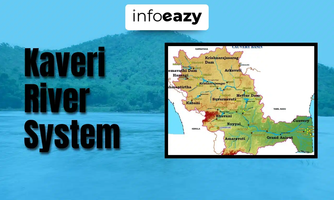
The Kaveri River flows through the states of Karnataka, Tamil Nadu, Kerala, and the Union Territory of Puducherry. Kaveri is a perennial river, meaning it flows all year round, mainly fed by Monsoon Rains – the Southwest Monsoon in Karnataka and the Northeast Monsoon in Tamil Nadu. Along its journey, it is joined by several important tributaries like Hemavati, Shimsha, Arkavati, Bhavani, Kabini, and Amaravati. Originating in Karnataka, it flows southeast through Tamil Nadu, forming several waterfalls, including the famous Shivanasamudra Falls. It forms a broad delta in Tamil Nadu before entering the Bay of Bengal. The river is vital for irrigation in both Karnataka and Tamil Nadu.
Kaveri River System Details
Kaveri River flows through three South Indian States of Karnataka, Tamil Nadu, and Kerala, and also through the Union Territory of Puducherry. Originating in the Kodagu (Coorg) District of Karnataka, it flows for approximately 800 km before merging with the Bay of Bengal, near Poompuhar in Tamil Nadu.
| Kaveri River System Details | |
| Particulars | Details |
| Flow in States | Karnataka, Tamil Nadu, Kerala, Puducherry |
| Important Cities on its Banks | Karnataka: Madikeri, Mysuru, Mandya, Srirangapatna |
| Originates from | Talakaveri, Brahmagiri Hills, Kodagu District, Karnataka, India |
| Total Length | 800 KM |
| Disperses into | Bay of Bengal (near Poompuhar, Tamil Nadu) |
Kaveri River System Origin
The Kaveri River originates at Talakaveri in the Brahmagiri Hills of the Western Ghats, located in Kodagu (Coorg) District, Karnataka, at an altitude of about 1,341 meters. Although the source is considered sacred, the river initially flows underground for a short distance before emerging and flowing generally southeast across southern India. The Kaveri forms one of the most fertile deltas in India, the Kaveri Delta in Tamil Nadu, known as the “Rice Bowl of Tamil Nadu.” The delta is rich in Alluvial soil and supports extensive agriculture, especially the cultivation of paddy (rice), sugarcane, and bananas. The Kaveri Delta system covers a large area and is critical for food security in Tamil Nadu.
Also Read: Dams in India
Kaveri River System Tributaries
Kaveri River has 21 major tributaries. Major tributaries include:
| Kaveri River System Tributaries | |||
| Tributary | Origin | Joins Kaveri Near | Key Features |
| Hemavati River | Western Ghats, Chikmagalur district, Karnataka | Krishnarajasagara | Major tributary from Karnataka |
| Shimsha River | Tumkur district, Karnataka | Shivanasamudra | Known for Shimsha Waterfalls |
| Arkavati River | Nandi Hills, Karnataka | Near Kanakapura | Provides water supply to Bengaluru |
| Kabini River | Wayanad, Kerala | In Karnataka | Forms Kabini Reservoir; vital water source |
| Bhavani River | Nilgiri Hills (Tamil Nadu & Kerala) | Near Bhavani town, Tamil Nadu | Supports agriculture in Tamil Nadu |
| Amaravati River | Annamalai Hills, Tamil Nadu | Near Karur, Tamil Nadu | Longest tributary; flows through fertile districts of Udumalpet, Dharapuram etc. |
Kaveri River System Catchment Area
The Kaveri River basin covers approximately 81,155 Sq. Km. spanning across four states and a Union Territory. The basin supports diverse ecosystems, industries, and agriculture.
| Kaveri River System Catchment Area | ||
| States/UT | Catchment Area (Sq. Km.) | Catchment Area in Percentage |
| Karnataka | 34,273 | 42.2% |
| Tamil Nadu | 43,856 | 54.0% |
| Kerala | 2,866 | 3.5% |
| Puducherry | 160 | 0.3% |
Kaveri River System Ecology
The Kaveri Basin is divided into Two Main Ecological Zones: Forest and Agricultural land. Its forests include dry deciduous, evergreen trees, and grasslands. Around 12,850 sq. km of forest was lost between 1965 and 2016 due to human activities. The region hosts diverse plant species such as the Arjun tree, Tamarind, Banyan, and Peepal trees. Several protected areas within the basin support key wildlife like tigers and elephants. Other fauna include Indian bison, leopards, sloth bears, Nilgiri tahr, grizzled giant squirrels, and various deer species. The basin is rich in birdlife, including painted storks, spot-billed pelicans, and ibises. It also supports aquatic species like the mugger crocodile, smooth-coated otter, and the endangered Hump Backed Mahseer Fish.
Kaveri River System FAQs
Q1. Where does the Kaveri River originate?+
Q2. Which States does the Kaveri River flow through?+
Q3. What are the Major Tributaries of the Kaveri River?+
Q4. Where does the Kaveri River discharge its water?+
Q5. Why is the Kaveri River important?+
Tags: Kaveri River Kaveri River System