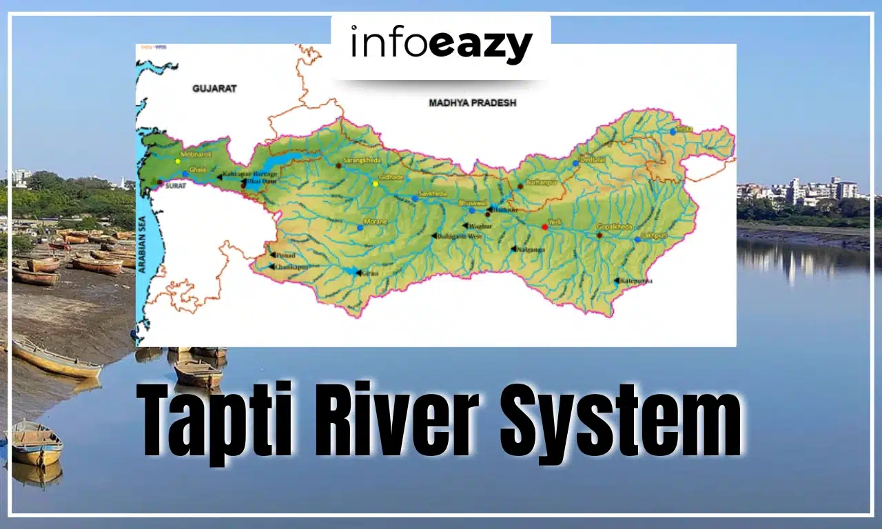
The Tapti River, also spelled as Tapi, is one of the major west-flowing rivers in India. Originating in Madhya Pradesh and flowing westwards into the Arabian Sea, the river holds geographical, ecological, and economic significance. Spanning a length of approximately 724 km, the Tapti is among the few rivers in peninsular India that flow from east to west, a characteristic it shares with the Narmada and Mahi rivers.
The river plays a vital role in the livelihoods of the population across Madhya Pradesh, Maharashtra, and Gujarat, supporting agriculture, domestic needs, and industries. Major cities such as Burhanpur, Bhusawal, Jalgaon, and Surat lie on its banks, benefiting from its water and fertile plains. The Tapti River system, enriched by several tributaries, nourishes a vast and diverse river basin across central and western India.
Tapti River System Origin
The Tapti River originates from the Multai reserve forest in the Betul district of Madhya Pradesh, at an elevation of around 752 meters above sea level. This location lies within the Satpura range, a prominent mountain range in central India. The river begins its journey flowing westward across the Deccan Plateau before finally emptying into the Arabian Sea via the Gulf of Cambay (also known as Gulf of Khambhat).
The Tapti River is often referred to as the “twin” or “handmaid” of the Narmada River due to its similar westward flow and location. It traverses through three Indian states, Madhya Pradesh, Maharashtra, and Gujarat, draining a basin area of about 65,000 square kilometers. The river flows through Vidarbha, Khandesh, and South Gujarat, regions known for their agricultural output and dense population centers.
Other Related Post: Kaveri River System
Tapti River System Tributaries
The Tapti River System is supported by several important tributaries, both on its left and right banks. Together, these tributaries contribute significantly to the river’s flow, hydrology, and basin ecology. Among these, the Purna River is the most prominent tributary, contributing from the left bank and draining a vast area. Below is a list of notable Tapti River tributaries:
| Tapti River System Tributaries | ||||
| Tributary | Description | Drainage Area (sq. km) | Length (km) | Direction of Flow |
| Purna | Major left-bank tributary; the only river flowing in the upper basin of peninsular India | 18,929 | – | Left bank |
| Girna | Named after Goddess Parvati, it originates in the Western Ghats and flows north | 10,061 | – | North |
| Bori | Originates in Nashik, Maharashtra; flows east and then north to meet the Tapti | 2,580 | – | East, then North |
| Panjhra | Originates near a small town; Latiapada Dam is built near its source | 3,257 | – | – |
| Aner | The largest right-bank tributary of the Tapti | 1,702 | – | Right bank |
| Arunavati | Flows from Satpura range to the southern slopes, covering 64 km on the left bank before merging with Tapti | – | 64 | Left bank |
| Gomai | Originates in the Satpura range and flows towards the southern slopes; right-bank tributary | 1,148 | 58 | Right bank |
| Waghur | Originating in the Ajanta range and flowing north, a left-bank tributary | 2,592 | 96 | Left bank |
| Burray | Originates in the Satmala range and flows east before meeting the Tapti | 1,419 | 64 | East |
Tapi River Basin
- The Tapi River Basin stretches across Madhya Pradesh, Maharashtra, and Gujarat, covering a total area of approximately 65,145 sq.km. It has a maximum length of 534 km and an average breadth of 196 km, forming a unique river basin on the Deccan Plateau.
- The basin is naturally bounded by various hill ranges: the Satpura Range in the north, the Mahadev Hills in the east, the Ajanta and Satmala Ranges in the south, and the Arabian Sea in the west. This physiographic layout results in a diverse landscape comprising hilly uplands in the upper basin and fertile alluvial plains in the lower region.
- Agriculture is the dominant land use in the basin, accounting for over 66% of the total area. Major crops include cotton, sugarcane, and pulses. Water bodies make up around 2.99% of the basin area, supporting drinking water supply and industrial use, especially in Gujarat and southern Maharashtra.
Tapi River Soil Type
The Tapi River basin is largely characterized by black soil, also known as regur soil, which is highly fertile and ideal for cotton cultivation. In Gujarat’s coastal areas, alluvial clays with a top layer of black soil dominate the landscape, making the region agriculturally rich and productive. This variation in soil types supports a mix of dryland farming and irrigated agriculture, depending on the availability of water and topography. Soils in the Tapti basin up to the Ukai Dam are generally categorized into three types:
- Coarse Shallow Soils – Found in the upper reaches and hilly areas.
- Medium Black Soils – Cover much of the central basin, supporting various crops.
- Deep Black Soils – Found in the lower reaches and near the river mouth, ideal for cash crops.
Tapti River System FAQs
Q1. Where does Tapi River start and end?+
Q2. What is the drainage system of Tapti?+
Q3. Does Tapti River form a delta?+
Q4. What is the largest tributary of Tapti?+
Q5. Which city is famous on Tapi River?+
Tags: Tapti River System